News

CanVis can Help you Visualize Your Landscaping Vision

Written by: Jason Gordon, Associate Professor of Community Forestry

Late winter and early spring is the time when homeowners start thinking about landscaping for the new year. This article introduces you to a free software application that serves as a tool to visualize landscape ideas and scenarios.  

CanVis is a software application developed by the National Oceanic and Atmospheric Agency and the National Agroforestry Center. Its original purpose was to visualize future coastal changes related to sea level rise. However, this free software also allows users to “see” how their yards, gardens, and other landscapes would appear using photographic simulation. CanVis is similar to Photoshop but with less of a learning curve. Users can “test” the way a landscape design looks before picking up a shovel! An article from Warnell Outreach (WSFNR-19-49 CanVis Photorealistic Visualization) provides step-by-step exercises to help beginners become familiar with the software.  

CanVis can be downloaded at https://toolkit.climate.gov/tool/canvis. 

Visualization tells a story. This means making it as realistic as needed for the purpose of the project. The user can create trees and other vegetation as well as create images of people, animals, and objects like cars. The CanVis online library has hundreds of images that can be downloaded free of charge.  

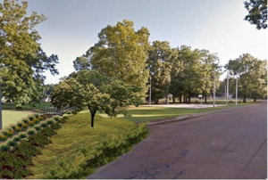
Angle, scale, and lighting should be relevant to the project objective. Example 1 shows a tree as it might look after pruning major limbs. This photo makes the homeowner more comfortable with the prescription. The simulation can also help the arborist plan the activity. Example 2 depicts some vegetation improvement in a park. This is a fairly simple simulation with a tree and groundcover added to the original landscape. The simulation shows how the drainage area can be “hidden” using appropriate plantings. The amount of detail depends on the project objective; for example, a conceptual mock-up may not need a lot of detail to get the point across. 

While CanVis is an easy software to learn, it takes some practice to gain proficiencyUsers should be familiar with managing ZIP files, using image editing software (e.g., Paint), and basic computer file management. Once the user becomes proficient, CanVis becomes a powerful tool to plan and communicate landscape designs.  

CanVis can Help you Visualize Your Landscaping Vision

Written by: Jason Gordon, Associate Professor of Community Forestry

Late winter and early spring is the time when homeowners start thinking about landscaping for the new year. This article introduces you to a free software application that serves as a tool to visualize landscape ideas and scenarios.  

CanVis is a software application developed by the National Oceanic and Atmospheric Agency and the National Agroforestry Center. Its original purpose was to visualize future coastal changes related to sea level rise. However, this free software also allows users to “see” how their yards, gardens, and other landscapes would appear using photographic simulation. CanVis is similar to Photoshop but with less of a learning curve. Users can “test” the way a landscape design looks before picking up a shovel! An article from Warnell Outreach (WSFNR-19-49 CanVis Photorealistic Visualization) provides step-by-step exercises to help beginners become familiar with the software.  

CanVis can be downloaded at https://toolkit.climate.gov/tool/canvis. 

Visualization tells a story. This means making it as realistic as needed for the purpose of the project. The user can create trees and other vegetation as well as create images of people, animals, and objects like cars. The CanVis online library has hundreds of images that can be downloaded free of charge.  

Angle, scale, and lighting should be relevant to the project objective. Example 1 shows a tree as it might look after pruning major limbs. This photo makes the homeowner more comfortable with the prescription. The simulation can also help the arborist plan the activity. Example 2 depicts some vegetation improvement in a park. This is a fairly simple simulation with a tree and groundcover added to the original landscape. The simulation shows how the drainage area can be “hidden” using appropriate plantings. The amount of detail depends on the project objective; for example, a conceptual mock-up may not need a lot of detail to get the point across. 

While CanVis is an easy software to learn, it takes some practice to gain proficiencyUsers should be familiar with managing ZIP files, using image editing software (e.g., Paint), and basic computer file management. Once the user becomes proficient, CanVis becomes a powerful tool to plan and communicate landscape designs.  

Categories

Archives